loading ...
The digital transformation strategy of Riyadh Municipality has laid the foundation for launching smart city initiatives through one of its key objectives: "Providing advanced use cases for operations by adopting emerging technologies and promoting innovation to enhance the municipal sector." Some of these initiatives have already been implemented, showing positive results and impacts, while efforts to develop innovative solutions for further progress continue. For more information about the Smart Cities Initiatives, please visit the following link.
The Municipality has invested in Emerging Technologies and Modern Technologies in developing its business system and services, such as using the Internet of Things to control irrigation sensors, analyze sensor data, and rebuild proactive plans to confront challenges.
Riyadh Municipality adopted artificial intelligence (AI) technologies across various domains, observing the ethical principles of AI issued by Saudi Data and Artificial Intelligence Authority (SDAIA). Key applications include:
These initiatives reflect Riyadh Municipality’s commitment to deploy modern technologies and AI to improve the quality of services provided to residents while enhancing sustainable urban development in the city.
Cloud Computing
The Riyadh Municipality has been at the forefront of embracing and adopting modern technologies to enhance the efficiency of digital services for Riyadh’s residents. Cloud computing plays a crucial role in providing, developing, and delivering technological resources on demand, improving service accessibility by making the municipality’s electronic services available online to citizens and residents anytime and from anywhere.
In compliance with the Digital Government Authority's directives for government entities to achieve digital transformation, the Riyadh Municipality has undertaken several projects to shift from traditional IT infrastructure to cloud-based infrastructure. This transition has led the Riyadh Municipality to rank first in the 2024 Digital Transformation Index among the 13 regional municipalities in Saudi Arabia and to compete at the innovation stage for the eighth position across all government sectors and ministries.
The Riyadh Municipality recognizes the significant potential of cloud computing in reducing IT infrastructure costs. By leveraging this technology, the municipality lowers financial expenses related to hardware maintenance, data centers, and energy consumption, while streamlining the integration of computing systems and core tools to improve operational efficiency and simplify administrative processes.
Additionally, cloud computing enhances data protection and privacy through advanced security encryption technologies and modern access control methods such as two-factor authentication (2FA), which helps prevent cyber threats. Cloud solutions also enable reliable system backups, ensuring the protection of sensitive information. Furthermore, cloud technology facilitates big data processing, empowering decision-makers with data-driven insights for more effective governance.
The Municipality has adopted specific actions and policies regarding cybersecurity. These include authorized digital certificates, as the Riyadh Municipality e-portal is using one of the best international companies in this field, the DigiCert Company. It also employs Secure Socket Layer (SSL), which provides high confidentiality to information through encrypting them. The information stored in the databases is also encrypted. Managing passwords with high restrictions to secure access and other actions of cybersecurity.
Digital Identity E-Identity (e-ID)
The Riyadh Municipality’s Digital Transformation Strategy focuses on the reuse of the eGovernment key enablers developed on the national level, such as Digital Identity, Digital Signatures and Public Key Infrastructure, Interoperability and Shared Government Data Exchange, ePayment Channels, Digital Post, etc. As this is stated in one of the strategic objectives which is “Enabling technical integration between the government and private sectors to provide data and facilitate services”, Riyadh Municipality had reused the National Single Sign-On system as a digital ID for their beneficiaries to access the municipality services.
Building Capacity
One of the success criteria for Riyadh Municipality’s Digital Transformation Strategy was focusing on “Technical empowerment of Riyadh municipality’s employees” by raising their digital capabilities and skills in the areas of digital transformation, innovation, emerging technologies, and smart cities. In order to build a capable team from different deputyships to interact effectively with digital transformation goals and objectives.
Mobile Applications
The Riyadh Municipality’s Digital Transformation Strategy focuses on developing the most convenience interactive channels such as Mobile Applications for their beneficiaries, In accordance to the following strategic objectives:
1- “Providing an interactive environment and digital channels for residents to raise their participation and take their suggestions regarding municipal services”.
2- “Meeting the aspirations and needs of beneficiaries by improving services and improving their experience”.
Hence, The Municipality develops and uses mobile applications to make interaction with the portal easy, flexible and efficient. For example, “مدينتي My City” mobile application enables the citizen to communicate anytime with the Riyadh Municipality Emergency Center in order to provide the latest methods that contribute to the delivery of communications to the Municipality.
Optical distortion detection and treatment program
Based on Riyadh Municipality's approach of providing smart solutions to enable departments and sub-municipalities of providing control and inspection services, the technical team in Riyadh Municipality has developed a Mobile Application, aiming at facilitating the workflow of field teams in monitoring and reporting the visual distortion elements in Riyadh city, which allows users to review, examine and record distortion elements types and taking photos, as well as automatic determination of location coordinates on the map, where optical distortion element has monitored, and forwarding the report to the competent authorities to be processed, documented and escalated to the central operation room.
System Features
Determines location coordinates of visual distortion elements on the map automatically.
Integration with GIS service in Riyadh Municipality, where observers’ location is determined based on mapping coordinates automatically.
Helps supervisors of sub-municipalities and central departments to follow up and review tasks, which are required to be completed.
Provides automatic image capture mechanism for documentation (before and after).
Assists in monitoring and reviewing visual distortion elements and taking the needed action.
Enables cooperative population to participate in reporting some sites, to be forwarded by the App. to supervisors directly.
Distributing and determining routes on maps, to assign tasks to sub-municipalities’ observers.
Geographic Information Systems Technology (GIS)
Using GIS interactive map to facilitate the management of large areas within the geographical scope of Riyadh city, to organize access of municipal observers to all districts and streets in the city, through defining the scope of each sub-municipality separately, and then determining the scope of districts of each sub-municipality separately, then starting the process of creating routes for all branched streets in each district and each sub-municipality, those routes are used to create tasks, which will be assigned to observers periodically, based on calculations to ensure coverage of all sub-municipalities and districts.
Using GPS feature on the application, which is integrated with the system, to do the process of organizing registered reports to observers of sub-municipalities and districts, it :
Allows observers to monitor reports within the specified determined route only, where they can not work outside the specified scope of work.
Automatic identification of report registration process, where it is sorted and classified according to coordinates, and registering report by (Sub-Municipality and District) where it is located.
Tracks observers’ route on the map, and compares the workflow with the determined route, to ensure covering all routes on the ground of reality.
Weight Change Sensors in transport trucks of construction waste
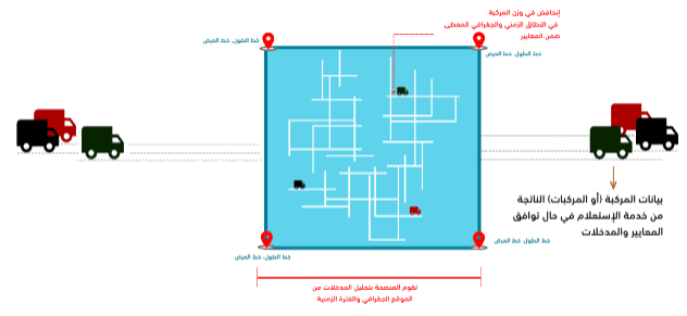
Sensors are installed to monitor the weight change of trucks, where they are connected directly through an Internet connection, and when change happens in a load of the truck by a certain percentage, it records the truck data with the weight change, as well as sending the location coordinates on the map to determine the location of change, while system retrieves data of recorded tracks in weight change item for sending an observer to check for the violation in the registered site.
Municipal Waste Management System (MWMSR)
Emerging technologies and recent trends
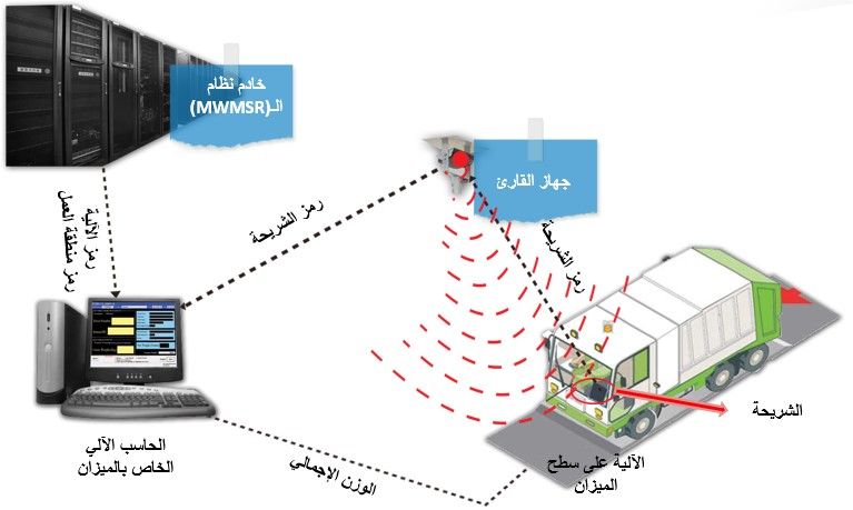
1- Electronic identification technology using radio frequencies (RFID)
Technology description
It is a wireless technology used to electronically identify the vehicles that reach the cemetery and transitional stations through chips that are installed on those vehicles.
The goal of the technology
Reaching the system to the highest levels of efficiency and accuracy
Reducing the time spent on procedures
2- Mobile Apps System
The MWMSR mobile application has been developed to:
View forms, reports, and data via mobile devices.
Increase the effectiveness of monitoring operations in the field and reduce the cycle of correction and processing observations.
As a first stage, it has been introduced and adopted the application for each of the following:
Summary of operations in compressor working areas.
Locate containers and barrels locations.
Upload the photos of field notes.
No comments have been added yet
Last Update:
06/28/2026
0 visitors liked the page content out of 0 shares