Email

Air Quality Index

Weather Icon

°C

My City

Questions

ع
Amana Logo
  • About Us
    • About Us
    • about riyadh
    • AlRiyadh Princes
    • AlRiyadh mayors
    • Amana Strategy
    • Digital Strategy
    • RM Council Meetings
    • Conditions & Regulations
    • Organization Chart
    • municipalities
    • initiatives
    • Riyadh Muncapility Budgets
    • Tenders and Procurements
    • Investment Opportunities
    • sustainable development
    • Publications
    • RM Partners
    • eservices stats
    • portal statistics
    • Last Portal Updates
  • Development Sectors
  • Services
    • Municipality Services
    • Governmental Services
    • Proactive Services
  • Media
    • News
    • Image Gallery
    • Videos Gallery
    • Events & Announcements
    • Add Idea
    • Guest Service Center
    • Customer Experience Center
    • Contact the Private Sector
    • awards
  • Open Data
    • Open Data
    • Request / Provide Open Data
    • Sharing Data
    • Open Data Guidance
  • Participation
Beta Launch
Logo
Beta Launch
  1. Home
  2. About Al-Riyadh
Al Riyadh Logo

Report 940

Riyadh Municipality - Raqmi CertifiedVision 2030 Logo
Overview
  • About us
  • About RM Portal
  • Privacy and confidentiality of information
  • Terms of use
  • News
  • News Letter
  • Subscribe to Weather
  • Subscribe to Natural Disasters
  • Service Level
  • Portal Performance Statistics
  • Service Statistics Dashboard
  • Add Idea
  • Photos and Sends
  • Safe Use of Apps Policy
Help and Support
  • Contact Us
  • Raise a Complaint
  • Reporting Corruption
  • Frequently Asked Questions
  • Unified Support Center
  • Technical Support in Sign Language
  • Right of Access Policy
  • Report Fake News
Important Links
  • Riyadh Guide and Events
  • Employment
  • Ministry of Municipal and Rural Affairs
  • Balady Platform
  • Gov.sa
  • Balady App
  • Open Data Platform
  • Legal Consultation Platform
  • Community Participation Platform
  • Royal Commission
  • Real Estate Consultant
  • Important Contacts
  • Riyadh Oases
  • Sakani

All rights reserved to the Riyadh Municipality © 2025

Site Map

Last Updated: 25/05/2025

  1. Home
  2. about us

Riyadh History

The first inception of Riyadh began about three centuries ago, on part of the site of the ancient city of Hajar, which remained for tens of centuries the base of the province of Al Yamamah and a center for the confluence of trade caravan routes that roam around the island between its north and south, east and west, and its location is characterized by many valleys and wells with abundant water, palms, planting and fruits. Riyadh grew in this privileged location a small village, surrounded by other villages on the site of the extinct city of Hajar and surrounded by a sprawling desert over the Najd plateau, then the city continued to grow at natural rates and expanded its area during that period. Now the city of Riyadh represents a unique and wonderful model in the field of urban growth and unprecedented achievement, so Riyadh began to develop urbanly during the last quarter of the last century to take a new turn, the rapid reconstruction movement was launched throughout the city and its surroundings in an amazing way, creating a large number of new districts, accompanied by huge plans to establish various municipal projects of roads, bridges, modern intersections, lighting, car and pedestrian tunnels, multi-storey parking, gardens, parks, children's playgrounds, fountains and aesthetic shapes, public markets, commercial centers, health slaughterhouses, and other modern equipment and facilities, in addition to educational, health and social services, communication and transportation services of all kinds.

Riyadh History

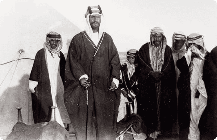
The name **"Riyadh"** began to be used for the city in the 11th century AH, based on what Ibn Bishr mentioned in his historical account: *"In the year 1049 AH / 1639 CE, the judge of Riyadh passed away."* The name **"Hajr"** gradually faded and was no longer used except to refer to a small part of the old city, and later to a water well located on the western bank of Wadi Al-Batha within Riyadh, between today’s King Saud Street (formerly Al-Batha Street) and King Faisal Street. The new name, **"Riyadh,"** came to encompass what remained of the city of Hajr along with the surrounding lands and orchards. The name was derived from the nature and landscape of the area, known for its greenery and gardens. The unity of the city became more evident with the construction of the mud wall around it in 1162 AH / 1748 CE. — *Hamad Al-Jasser*

The stages of development of Riyadh city during the reign of King Abdulaziz

  • 1350 AH:

    Implementation of the General Plan for the Settlement of Bedouins
  • 1353 AH:

    Oil began to be exported from the Kingdom, and its revenues benefited from reconstruction and development
  • 1365 AH

    Opening of the old Riyadh Airport
  • 1366 AH

    Electricity enters the city of Riyadh
  • 1367 AH:

    Opening of Riyadh and Dammam Railway to connect the capital with the Eastern Province
Timeline Image
Population

Riyadh Population

%35.81%35.81

%35.81

Percentage of non-Saudi residents

%64.19%64.19

%64.19

Saudi nationals

4%4%

4%

Population growth rate

6.51 M6.51 M

6.51 M

Total population

Geographical location

Al Riyadh Map
commment icon

Comments and Suggestions

For inquiries or comments regarding municipal services, please fill in the required information.

Your Comment

Comments

No comments have been added yet

Your Rating
★★★★★
(2Reviews)

Last Update:

05/13/2025


Was the content helpful?

16 visitors liked the page content out of 16 shares